The 'prior wind affected areas' graphical product indicates the regions already affected by a tropical cyclone's high wind speeds. Specifically the product gives the maximum possible extent of areas previously and currently affected by 1-min sustained winds of hurricane Cat 1 strength (in yellow) and/or by 1-min sustained winds of tropical storm (TS) strength (in light green). This information is provided for all active tropical cyclones worldwide. The product will benefit humanitarian relief by indicating the regions likely to be worst-affected by a storm so that aid may be prioritised. It may also help improve the organisation and efficiency of insurance claims management.
The 'prior wind affected areas' are computed from the storm quadrant wind radii given in the zero-lead advisories received from the tropical cyclone warning centres. Since the coloured regions indicate the maximum possible extent of a given wind speed, not all locations falling within the marked areas will necessarily have experienced 1-min sustained winds at the level shown. The graphic is updated every 6 hours except for the North Indian and Southern Hemisphere basins where updates occur every 12 hours.
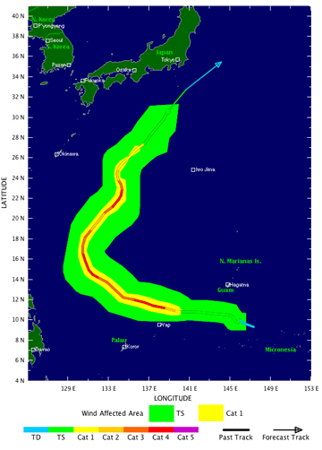
Example 'prior wind affected areas' graphic (right) for Super Typhoon Nesat in the Northwest Pacific as of 12:00 GMT on June 10, 2005. The display includes the storm's centre track and peak 1-min sustained wind speed coloured-coded.
