| Time |
Position |
Strength |
Wind Probabilities |
Wind Model |
| GMT |
Lead |
Lat |
Long |
Peak Wind |
Cat |
TS |
Cat 1 or Above |
Wind Field |
|
12 Aug, 9:00
|
0
hrs
|
17.4 N
|
34.3 W
|
40 kts
|
TS
|
Click Here
|
Click Here
|
N/A
|
FORECAST DATA
Forecast lead times used by TSR are referenced to the current data time. These lead times differ from those used by the US National Hurricane Center which are referenced to the current data time minus 3 hours.
PAST DATA
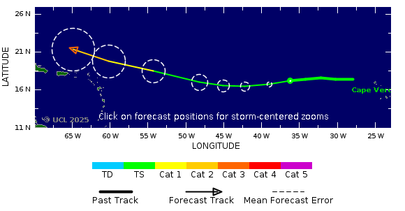
PAST AND FORECAST TRACK
|
|
| Tropical Cyclone Windspeed Scale* |
|---|
| Strength | Category | 1 Minute Maximum Sustained Winds |
|---|
| knots | mph | km/h |
|---|
| Tropical Depression | TD | <34 | <39 | <63 |
| Tropical Storm | TS | 34-63 | 39-73 | 63-118 |
|
Hurricane
| Cat 1 | 64-82 | 74-95 | 119-153 |
|
Hurricane
| Cat 2 | 83-95 | 96-110 | 154-177 |
|
Intense Hurricane
| Cat 3 | 96-112 | 111-129 | 178-208 |
|
Intense Hurricane
| Cat 4 | 113-136 | 130-156 | 209-251 |
|
Intense Hurricane
| Cat 5 | >136 | >156 | >251 |
|
*Note that the windspeed scale used here is the Saffir-Simpson hurricane wind scale. This differs from wind scales used by regional agencies other than the National Hurricane Center. The category applied to a storm on this site may differ from the category applied by an official regional meteorological agency.
