Tropical Storm Risk (TSR)
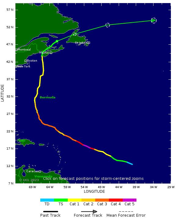
Post-Tropical Storm LEE: Current Data (Final Warning)
| Time |
Position |
Strength |
Wind Probabilities |
Wind Model |
| GMT |
Lead |
Lat |
Long |
Peak Wind |
Cat |
TS |
Cat 1 or Above |
Wind Field |
|
17 Sep, 15:00
|
0
hrs
|
48.0 N
|
62.0 W
|
40 kts
|
TS
|
Click Here
|
Click Here
|
N/A
|
FORECAST DATA
Forecast lead times used by TSR are referenced to the current data time. These lead times differ from those used by the US National Hurricane Center which are referenced to the current data time minus 3 hours.
PAST DATA
PAST AND FORECAST TRACK
|
|
| Tropical Cyclone Windspeed Scale |
|---|
| Strength | Category | 1 Minute Maximum Sustained Winds |
|---|
| knots | mph | km/h |
|---|
| Tropical Depression | TD | <34 | <39 | <63 |
| Tropical Storm | TS | 34-63 | 39-73 | 63-118 |
|
Hurricane
| Cat 1 | 64-82 | 74-95 | 119-153 |
|
Hurricane
| Cat 2 | 83-95 | 96-110 | 154-177 |
|
Intense Hurricane
| Cat 3 | 96-112 | 111-129 | 178-208 |
|
Intense Hurricane
| Cat 4 | 113-136 | 130-156 | 209-251 |
|
Intense Hurricane
| Cat 5 | >136 | >156 | >251 |
|

|
Researched and Developed by
Mark Saunders,
Frank Roberts
and
Adam Lea
TSR Version 4.1 Copyright © 2023
EuroTempest
, London,
UK
Last updated on
17 Sep, 2023 14:43 GMT

|

|