| Time | Position | Strength | Wind Probabilities | Wind Model | ||||
|---|---|---|---|---|---|---|---|---|
| GMT | Lead | Lat | Long | Peak Wind | Cat | TS | Cat 1 or Above | Wind Field |
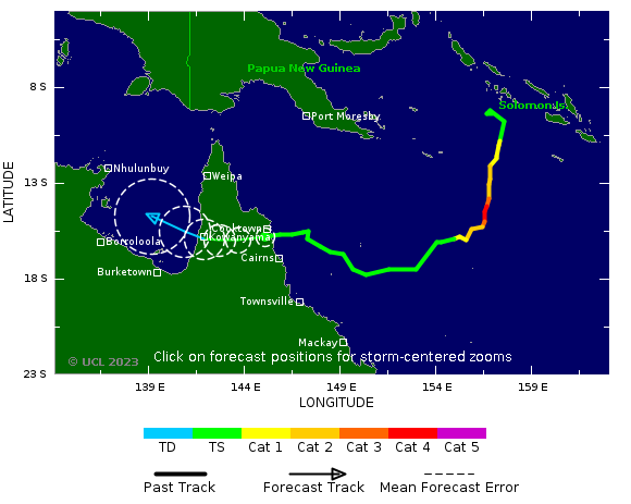
| 13 Dec, 12:00 | 0 hrs | 15.8 S | 145.0 E | 50 kts | TS | Click Here | Click Here | N/A |
| Time | Position | Strength | Wind Probabilities | Wind Model | ||||
|---|---|---|---|---|---|---|---|---|
| GMT | Lead | Lat | Long | Peak Wind | Cat | TS | Cat 1 or Above | Wind Field |
| 14 Dec, 0:00 | 12 hrs | 16.0 S | 143.6 E | 40 kts | TS | To 12 hrs | To 12 hrs | N/A |
| 14 Dec, 12:00 | 24 hrs | 16.0 S | 142.6 E | 35 kts | TS | To 24 hrs | To 24 hrs | N/A |
| 15 Dec, 0:00 | 36 hrs | 15.9 S | 141.8 E | 30 kts | TD | To 36 hrs | To 36 hrs | N/A |
| 15 Dec, 12:00 | 48 hrs | 15.5 S | 140.8 E | 30 kts | TD | To 48 hrs | To 48 hrs | N/A |
| 16 Dec, 12:00 | 72 hrs | 14.7 S | 139.1 E | 30 kts | TD | To 72 hrs | To 72 hrs | N/A |
| Current Update | 13 Dec, 2023 12:00 | Prior Wind Affected Areas | TS and Cat 1 Winds |
|---|
|
|
||||||||||||||||||||||||||||||||||||||||||||||||||||||||||||||||||||||||||||||
