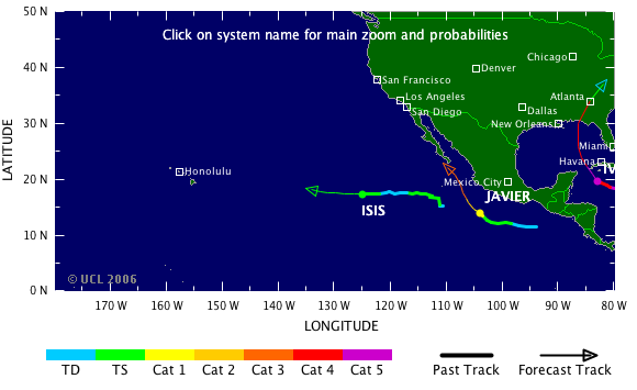
Tropical Storm Risk (TSR)

TSR logo
HOME | STORM TRACKER | FORECASTS | SKILL | ABOUT | PRESS | PUBLICATIONS | STAFF | POSTS | LINKS
There are 2 active NE Pacific systems as of 13 Sep, 3:00 GMT

Current Data 24-hr Ahead Projections
13 Sep, 2004 3:00 GMT 14 Sep, 2004 3:00 GMT
SystemBasin LatLongWindCat LatLongWindCat
ISIS NE Pacific 17.4 N 125.1 W 45 kts TS 17.4 N 128.4 W 50 kts TS
JAVIER NE Pacific 14.0 N 104.2 W 75 kts 1 15.7 N 106.1 W 95 kts 2
Storm Tracker Map
Current Satellite Images
RegionImage Type
Atlantic IRVisible
Atlantic WVIR En
NE Pacific IRVisible
NW Pacific IRW Vapour
Indian Ocean IRVisible
W Australia IRW Vapour
E Australia IRW Vapour
S Pacific IRW Vapour
Tropical Cyclone Windspeed Scale
StrengthCategory1 Minute Maximum Sustained Winds
knotsmphkm/h
Tropical DepressionTD<34<39<63
Tropical StormTS34-6339-7363-118
Hurricane Cat 164-8274-95119-153
Hurricane Cat 283-9596-110154-177
Intense Hurricane Cat 396-113111-130178-210
Intense Hurricane Cat 4114-135131-155211-250
Intense Hurricane Cat 5>135>155>250


Sponsors logos

Researched and Developed by Mark Saunders and Frank Roberts
TSR Version 4.0 Copyright © 2007 UCL University College London, Gower Street, London WC1E 6BT
Last updated on 17 Jan, 2007 12:00 GMT TSR passes W3C HTML 4.01 Quality Assurance

Regional map Regional map Regional map